Underwater Map--Bob Wentz Park

Please register or login

Welcome to ScubaBoard, the world's largest scuba diving community. Registration is not required to read the forums, but we encourage you to join. Joining has its benefits and enables you to participate in the discussions.

Benefits of registering include
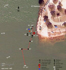
  • Ability to post and comment on topics and discussions.
  • A Free photo gallery to share your dive photos with the world.
  • You can make this box go away

Joining is quick and easy. Log in or Register now!

k-valve

Contributor
Scuba Instructor
Divemaster
Messages
1,408
Reaction score
0
Location
Austin, TX
# of dives
500 - 999
It's a work in progress, but I attached a copy of an underwater map of Bob Wentz Park...the public side of Windy Point on Lake Travis. As I add more details to the map I'll repost. Thought some of ya'll might get some use out of it.
 

Attachments

  • BobWentzPark.jpg
    BobWentzPark.jpg
    122.6 KB · Views: 1,909
Cool!

Some of those "stumps" are actually 30 foot trees. You might want to add the line that goes down to the river channel (it is at the base of a big tree,presumably the one labelled 94'. There is another big tree between the "94'"tree and the scoreboard. Depth is about the same )
 
Thanks for the map. I was a bit confused at first as my only trip to Bob Wentz was the summer of 2006 when the lake level was so low. Look forward to seeing the completed map.
 
Cool!

Some of those "stumps" are actually 30 foot trees. You might want to add the line that goes down to the river channel (it is at the base of a big tree,presumably the one labelled 94'. There is another big tree between the "94'"tree and the scoreboard. Depth is about the same )

Yep...that one at 94' is definitely a very tall stump. :) No worries about adding the line...it's in the "plan." I just started the map at 60' and up. I intend to add deeper items as I go. There's probably more junk out there to mark too. No tellin' what I missed in the low vis even doing sweeps at 5' increments.

You and Lance laid that line out to the river bottom didn't you? How far out/deep does that line go? I was down close to 160' on it once, but we had a little problem, silted ourselves out and decided to turn the dive.

I'm going to work on it a little more Saturday morning. If anyone wants to do some diving with a purpose let me know. I'd be glad to have the help. You can work as shallow, or deep, as you want. Heck, you don't even have to work...just come dive. :wink:
 
You and Lance laid that line out to the river bottom didn't you? How far out/deep does that line go? I was down close to 160' on it once, but we had a little problem, silted ourselves out and decided to turn the dive.

The line that drops down from the tree to the river Channel was (I think) put in by Mike Gault. It is gold cave line and very professionally laid. Ends at a stump just above the channel. Depth would be about 160 with a full lake.
Myself,Layne and Cyklon 300 extended it. From the stump it ducks under some tree branches,takes a left turn and heads south along the edge of the channel.After an 8-10 minute swim it heads up again,goes through a large bush and stops at around 120?? This is probably somewhere south of the scoreboard.Max depth probably 165.

The first part of the extended line,and the last bit are not at all well done as they go through trees. I want to tidy it up one of these days but that would require some decent viz which may not happen for a while. (Its kind of hard to pick the best path for a line when you can only see 12" !! )
 
Thanks for the cool map John. I've heard about a cool GPS trick if you want to add coordinates. They are not exact, but likely close enough. You need a Magellan GPS, a clear waterproof case and a finger reel. Basically, you enclose a Magellan GPS unit in a clear, waterproof case attached to a finger reel. When you want to mark a waypoint, you let the case float up, wait for 2 minutes and reel it back down. From what I understand, it has to be a Magellan GPS so that the screen will freeze when it looses signal.
 
Check this out-
Link- GPS Mapping of Underwater Sites

Wind and wave action can drive the unit to an unacceptable angle.
This is really good if you sensus Pro and you can tag the time and depth to the minute readout against the gps.

Also people have been known to pickup strange things- so add it to your float/flag.
Great use for milk crate.

or just buy a fishing map like I did :D

Andrew

That's way cool! Thanks! I'm thinking about mapping more of the lake just to give myself something to do besides blow bubbles and watch the catfish.:wink:
 
That's way cool! Thanks! I'm thinking about mapping more of the lake just to give myself something to do besides blow bubbles and watch the catfish.:wink:

Hi interesting work .... when you have more data let me know that we can create a virtual dive site (so you can dive the place from your home) :wink:

This video Virtual dive of the H.M.C.S. Yukon - San Diego - www.ediving.us can give an idea of what we are working on.

The simulator is available online here www.ediving.us.

Best Regards,

I_AM
 
https://www.shearwater.com/products/peregrine/

Back
Top Bottom