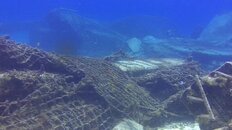
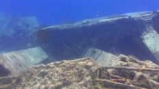
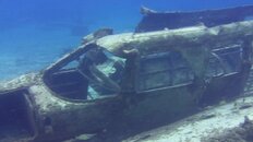
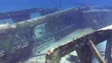
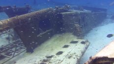
Been a few years but dived there many times. We usually giant stride from pier and head south (left). I don't recall the compass bearing so I'll set reference as straight out as west. It's probably not exactly that so adjust accordingly. If you head southwest, about 100 feet down the shore and 100 feet out, there is the wreckage of a small plane. People sometimes mention plane wreckage at La Ceiba but this is double the size of that. There are two sections of fuselage alongside each other and wings scattered around. From there head another couple hundred feet down the shore (south) and there i a huge amount of rubble from a major pier collapse. The rubble runs from shore to out 100-150 feet and then parallel to shore another 50 feet, making a giant ell shape.
I took some snaps from a few old videos but these were from years ago when the camera tech and my skills were much poorer. Currents at all shore dives tend to be minimal but not always. If current picks up and you are caught down current of exit point, head to shore line where it will dissipate. Worst case, pull yourself back on the rocks. It's not in the marine park and you can wear gloves. Always know your bearing to shore though you can navigate by depth. Right by the shore it's 10-15 feet, the plane is in 20-25, and the pier ranges from 15-25. If you hit 35-40 feet you went the wrong way and are getting close to the reef, lol. You can get away from identifiable rubble and find yourself in endless grass patches at 20 feet and it's hard to tell direction. Depth changes very gradually. Lots of boat traffic so avoid popping up to see unless emergency. Take a compass.
Edit: I originally got my directions crossed and said heading out was east. It is west from Hotel Barracuda to the mainland. It is southwest to the plane.


")
