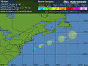
TD1 forms in Atlantic

Please register or login

Welcome to ScubaBoard, the world's largest scuba diving community. Registration is not required to read the forums, but we encourage you to join. Joining has its benefits and enables you to participate in the discussions.

Benefits of registering include

  • Ability to post and comment on topics and discussions.
  • A Free photo gallery to share your dive photos with the world.
  • You can make this box go away

Joining is quick and easy. Log in or Register now!

lamont

Contributor
Messages
7,562
Reaction score
648
Location
Seattle, WA
NHC advisory on newly formed TD1:

000
WTNT41 KNHC 281450
TCDAT1
TROPICAL DEPRESSION ONE DISCUSSION NUMBER 1
NWS TPC/NATIONAL HURRICANE CENTER MIAMI FL AL012009
1100 AM EDT THU MAY 28 2009

DEEP CONVECTION ASSOCICATED WITH THE AREA OF LOW PRESSURE OFF THE
MID-ATLANTIC COAST HAS BEEN PERSISTENT SINCE ABOUT 04Z THIS MORNING
WHILE THE SYSTEM MOVES OVER THE 25-26C WATERS OF THE GULF
STREAM. DVORAK CLASSIFICATIONS FROM TAFB AND SAB AT 12Z WERE
T2.0 AND T1.5...RESPECTIVELY. AN AMSU PASS AT 1033Z HELPS TO PLACE
THE CENTER ON THE NORTHWEST EDGE OF THE DEEP CONVECTION. BASED ON
THESE DATA...THE SYSTEM IS BEING UPGRADED TO A TROPICAL
DEPRESSION...THE FIRST OF THE ATLANTIC HURRICANE SEASON.

THE INITIAL MOTION IS 050/15. THE DEPRESSION IS EMBEDDED IN A
SOUTHWESTERLY STEERING CURRENT AHEAD OF A DEEP-LAYER TROUGH OVER
THE CENTRAL UNITED STATES. THIS BASIC PATTERN IS EXPECTED TO
PERSIST...AND THE DYNAMICAL MODEL GUIDANCE IS IN PRETTY GOOD
AGREEMENT...AT LEAST THROUGH 36 HOURS...WHEN THE SYSTEM BEGINS TO
LOSE DEFINITION IN MUCH OF THE GUIDANCE.

VERTICAL SHEAR OVER THE SYSTEM IS LIGHT...AND THE CYCLONE IS LIVING
OFF THE NARROW GULF STREAM WATERS. AS LONG AS IT REMAINS THERE SOME
STRENGTHENING IS POSSIBLE. ALTHOUGH THE SHIPS GUIDANCE DOES NOT
SHOW THE SYSTEM REACHING TROPICAL STORM STRENGTH...THE INITIAL SST
INPUT TO THE MODEL APPEAR TOO COLD. AS A RESULT...THE OFFICIAL
FORECAST WILL CALL FOR THE SYSTEM TO BECOME A TROPICAL STORM OVER
THE NEXT DAY OR SO. AFTER THAT...A LOSS OF CONVECTION...AND
TROPICAL CHARACTERISTICS...IS EXPECTED.

FORECAST POSITIONS AND MAX WINDS

INITIAL 28/1500Z 37.3N 71.0W 30 KT
12HR VT 29/0000Z 38.5N 68.4W 35 KT
24HR VT 29/1200Z 40.2N 64.6W 35 KT
36HR VT 30/0000Z 41.5N 60.0W 30 KT
48HR VT 30/1200Z 43.0N 55.0W 25 KT...EXTRATROPICAL
72HR VT 31/1200Z 46.0N 46.0W 25 KT...EXTRATROPICAL
96HR VT 01/1200Z...DISSIPATED

$$
FORECASTER FRANKLIN/BEVEN
 
And from Jeff Masters:

Wunder Blog : Weather Underground

Nature is jumping the gun a bit this year, with the season's first tropical depression forming four days before the official start to hurricane season. The area of disturbed weather (91L) that we've been watching, about 250 miles east-northeast of Cape Hatteras, North Carolina, has developed enough heavy thunderstorm activity and spin to be classified as a tropical depression. QuikSCAT imagery from last night revealed a closed surface circulation, but top winds of only 20 - 25 mph. Satellite estimates (using a cloud pattern recognition method called the "Dvorak" technique) were saying this was a tropical depression this morning, though, so the NHC elected to upgrade the system.

The disturbance is over the relatively warm waters of the Gulf Stream (25°C) and has wind shear of 5 - 10 knots over it, and these conditions are marginally favorable for some slow development to occur until Friday, when the system will likely move over waters too cold to support intensification. TD One is not a threat to any land areas. I give the storm a 60% chance of becoming Tropical Storm Ana.


Figure 1. Latest satellite image of TD One.

Is the formation of TD One a harbinger of an active hurricane season?
Probably not. Early season storms occurring near the U.S. coast have not been shown to be correlated with an active main portion of hurricane season during August - October. However, the situation is different if we start getting June and July storms in the deep tropics between Africa and the Lesser Antilles Islands. This was the case last year, when the formation of Hurricane Bertha in the deep tropics in July presaged an active 2008 hurricane season. According to the Hurricane FAQ, "as shown in (Goldenberg 2000), if one looks only at the June-July Atlantic tropical storms and hurricanes occurring south of 22°N and east of 77°W (the eastern portion of the Main Development Region [MDR] for Atlantic hurricanes), there is a strong association with activity for the remainder of the year. According to the data from 1944-1999, total overall Atlantic activity for years that had a tropical storm or hurricane form in this region during June and July have been at least average and often times above average. So it could be said that a June/July storm in this region is pretty much a "sufficient" condition for a year to produce at least average activity."
 
I refuse to acknowledge the existence of any hurricanes this year. :scorned:
 
where's DandyDon???!!! He's usually here posting hurricane info! :confused:
Only when Lamont is busy; he's better at it - altho I did have a thread on this storm under its previous ID.

at200901_5day.gif . at200901.gif
 
Only when Lamont is busy; he's better at it - altho I did have a thread on this storm under its previous ID.

I'm just more verbose. You usually get to it faster. =)

I should have known you'd have posted the Invest it formed from already... I didn't notice that until I was looking to see if I got the First Post for this year... Nope...
 

Back
Top Bottom