St Andrews Jetty Question ?

Please register or login

Welcome to ScubaBoard, the world's largest scuba diving community. Registration is not required to read the forums, but we encourage you to join. Joining has its benefits and enables you to participate in the discussions.

Benefits of registering include

  • Ability to post and comment on topics and discussions.
  • A Free photo gallery to share your dive photos with the world.
  • You can make this box go away

Joining is quick and easy. Log in or Register now!

idive2

Contributor
Messages
978
Reaction score
138
Location
Palm Beach County
# of dives
500 - 999
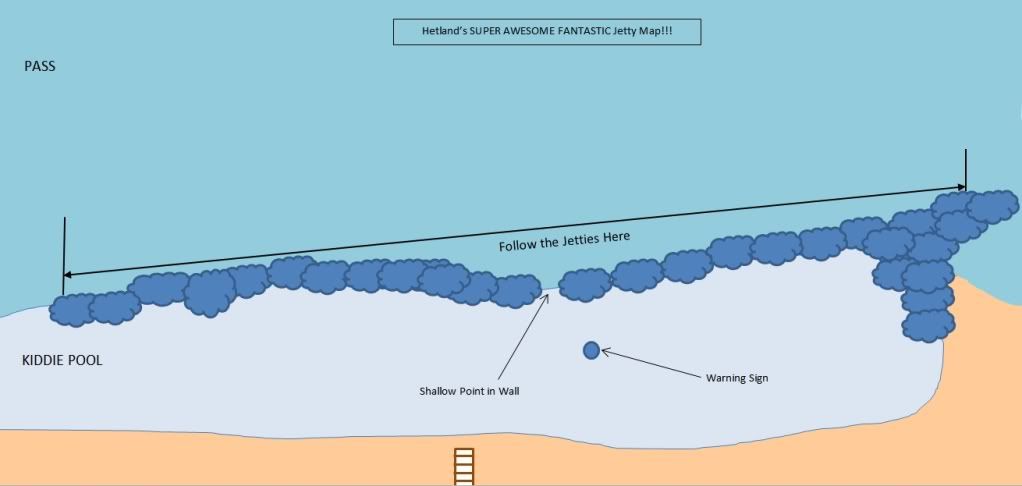
I checked out the maps on another thread and have a general idea of the jetty.
Are divers entering in the lagoon and starting at the shallow end of the jetty
or entering from the shore just west of the south end of the west jetty ? Also
is this west side of south end of the jetty pretty comparable to the channel
side of the jetty ? What is the usual dive as far as entrys and timing of the tides ?
 
I enter through a break in the rocks towards the center of the Jetty (see attached) and then travel deep (near where the sand and rocks meet) to the South or North. Once I hit my turn pressure or time, I ascend to a shallower depth (say, 20ft) and return to my starting point. You want to finish your second tank just before the end of high tide. Remember to factor surface intervals and tank changes into your schedule. Remember current is variable in both direction and strength, so plan your dive accordingly and build in a reserve on your gas pressure in case you have to hump it back against current. Also it's best to plant a flag at your entry/exit point, and tow a flag with you. It only takes getting hit in the head once by an ounce of lead to make a believer.

Clipboard02.jpg


Jetty_Map.jpg
 
Great information, thanks. I will probably just start with a one tank dive to get
familiar with the layout a bit more. When you mention planting a flag at the entry,
are you securing a seperate flag to some structure below the surface ? Is the break
in the jetty fairly obvious from below when returning or is the flag also a marker for your
return ? I will of course be towing a flag as well and will bring two in case I leave a
marker near my entry. Thanks again for the comments and maps.
 
If your going for the first time, you might be able to get up with some divers to show you around. You will have divers there most days.
 
That sure is a Super Awesome Fantastic jetty map!!!
 
Hetland gives great advice....especially about marking the point where you cross through the rocks. You think it will be obvious where the spot is to cross, but when the tide switches, and visibility drops, it is sometimes very difficult to find without a marker. Years ago my first dive at the jetties went to 1 foot visibility very quickly. We made a lot of hit and miss attempts before we found the spot where to cross back over. One diver got tired of trying and just climbed over the rocks....not a good dive plan.
 
Thanks Guys! Scubaboard didn't like the size of my map. Maybe Photobucket can do a bit better:


What you are seeing is because some folks (not you) post REALLY oversized pics. so SB added a hack that limits pic size to prevent page jam. So it does it to all pics over X size. (it posts them as a smaller image when [IMG] tags are used.


in these pics, you can always enlarge the pic by clicking on the yellow border at the top of the pic.

for example look for
nCode.png
Click this bar to view the original image of 800x380px.
 
Hetland,
Could you explain the tip on ending dives before end of high tide?
For example, if the chart shows high tide at 9:00 am, when will be end of high tide?
Thanks for information.
 

Back
Top Bottom