Navigation course ?

Please register or login

Welcome to ScubaBoard, the world's largest scuba diving community. Registration is not required to read the forums, but we encourage you to join. Joining has its benefits and enables you to participate in the discussions.

Benefits of registering include

  • Ability to post and comment on topics and discussions.
  • A Free photo gallery to share your dive photos with the world.
  • You can make this box go away

Joining is quick and easy. Log in or Register now!

The way the area works was a compromise to get it passed by the state.

Ah, a compromise! I see.

And the state was involved?

I feel much better then.

:cool2:
 
Strangely other than the initial regulations and needing fish and wildlife approval on materials used under water (make sure no fish are harmed), we have been able to have a huge amount of input and say. The compromise was to keep the fishermen from causing problems (some still think divers will ruin the lake).
 
so put a brick on each corner of the area, with an upline to a full size buoy, have a large dive flag on the dock, and make it clear that if the dive flag is up on the platform, then the boats have to stay on the *in this map* south side of the buoys. The issue you are going to have to figure out is that in order to make this a workable training area you have to have a means of controlled ascent and descent to at least one of the platforms for new students. This obviously has to be a big enough buoy so boats don't run into it. We use 8" PVC pipes which sit up quite tall and with SOLAS tape on it are visible at night.

You then have an issue with navigation of with their waypoints you now have to have catching features to keep them within that 10 acre area. That can be high viz polypro twisted line making a "fence" from the bricks holding the corner buoys back to the shore, or some other means of catching the divers. Other issue with waypoints is if you have uplines from each of the objects, you have to make the buoys big enough which make make the state grumpy because it impedes boat traffic. If you don't put buoys up, you now have to provide the bearings which takes parts of the skill out of it which is fine, just understand the limitations. You still need some sort of object to make sure that the divers are starting and leaving from the right spot. You can justify things like sunken cars and buses to the state by indicating that it will provide safe haven to encourage wildlife breeding and what not, which is true.

Advantage to a bus is it offers a HUGE learning opportunity for students. If you set the bus so it is perpendicular to the direction of travel, if the dive team is diving in proper navigation configuration *right diver as leader working with the compass, left diver with right hand on right divers left tricep monitoring depth and air*, then the dive team will tend to miss to the right. If you have them navigate to the left side of the bus, they will then have very good input based on where in the bus they hit as to their actual navigation accuracy.


Regarding fishermen, they are right. The fish will smarten up and realize that divers don't kill them, so they'll move into that area and be less available :)
 
One advantage when it comes to boat traffic is, the entire lake is idle speed. It's only 181 or so acres. The buoy I have on the one platform is made of 3" PVC pipe and sticks up at least one foot above the water. It is really obvious. The boundaries of the area are marked off with buoys and there is only one way in by boat.
 
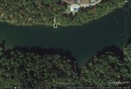
10010534_481363755328110_3066580541907303967_o.jpgHere is a view of the entire area. The white buoys are on the end toward the rest of the lake. The area to the Left of the pic is a dead end with water that goes to only a couple feet. I'm putting in a few underwater markers on the buoy down lines to help mark the area underwater.

So what do you think. Just the platform at one nav point then just buoys at the others? I would like it to be good for both OW and for the AOW classes.
 
So what do you think. Just the platform at one nav point then just buoys at the others? I would like it to be good for both OW and for the AOW classes.

I think one thing that you want to consider is ensuring a high likelihood of success for students. I'm not saying "dumb it down" but rather try to "keep it real" so that they actually learn and can be evaluated... rather than frustrated and failed.

Think about any real navigation a diver would find themselves doing. How often would a diver need to navigate in low vis between multiple waypoints that were not also identifiable/recognizable "points of interest" that could be relatively easily spotted once the diver got "close enough" to actually see them. For example, asking a diver to navigate from a platform - midwater, in low vis - to a bus that can't be seen from the starting point.
  • Obviously if the diver's navigation skills are perfect, the bus will begin to come into view directly ahead as the diver approaches it. Just as would be the case if someone was navigating towards something in the real world.
  • If the diver's nav is off just a little, the bus will still be readily apparent in front of the diver as they approach... abeit off to the left or right a little. Just as would be the case if someone was navigating towards something in the real world.
  • If the diver's nav is off significantly they might not see the bus until they went far enough distance-wise... and looked around and found the bus to be way off to their left or right instead of in front of them. Just as would be the case if someone was navigating towards something in the real world.
  • If the diver's nav is WAY off... well, they'll miss the bus. Both literally and figuratively.

Sure, navigation from a recognizable point-of-interest to something like a 5/8ths inch up-line as one waypoint, and then maybe to another recognizable point-of-interest is certainly fair game. But I'm not sure of the learning value of navigating between multiple "arbitrary" waypoints, and would expect student divers who were not already very good navigators to not do well and become frustrated.

Each of the scenarios in bullets above would be effective learning situations for every student. The same could not be said of course comprised of lines that even some small proportion of students missed and never found.
 
Good idea. I may put the one platform and the buoyancy course (small enough that you can miss it but not too small), and put something else on the nav course smaller than the other platform. I'm working on other items to put in but cars etc is a no go for now.
 
What about submerged buoys with a slate attached offering a compass heading to another way point or feature. It gives them a heading to start. Then their skills come in to play. How big should the sign be? Maybe large enough that they could see it from a couple yards? Too small and it could be just a source of frustration. too large and you make it too easy. Depends on your vis. Then how far between? If the vis at best is 20 feet perhaps double or triple that. The one thing to avoid in training is to make the objectives too hard. Too far apart and people start to doubt what the instruments are telling them. At first. I have no problem swimming for twenty minutes on a heading with no visual references. But that's taken years to get to that point. For students you want them building on successes. Even small ones. Not big things they might luck into or get turned off by.
 
  • Like
Reactions: RJP
Remember to place random objects along the navigation route for your students to memorize. Navigation often is 10% compass use and 90% keeping your eyes open and beeing aware of your surroundings and things you dive past (and to know how to find your way back).
 
https://www.shearwater.com/products/teric/

Back
Top Bottom