- Messages
- 2,195
- Reaction score
- 6
- # of dives
I'll dig our maps out and put the sites on the Goggle Map. I'm in. Great idea!!! Send out PM's to us when you are ready to commence work.


Welcome to ScubaBoard, the world's largest scuba diving community. Registration is not required to read the forums, but we encourage you to join. Joining has its benefits and enables you to participate in the discussions.
Benefits of registering include
")

can we use caloy's wreck photos? and mark it with PPD
sure go nuts, but I kind of like the icons that Penn used in his maps for wrecks.
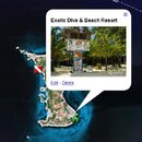
BTW, you can stick a photo(s) in the markers, as well as text, hyperlinks etc... This is what I did with Malapascua Exotic Resport.
edit: Oh, I'll have to research this more, but I think we might be able to create a overall PI map that just show single markers for the major sites - say PG, Anilao, PG, Coron, Subic, Tubbataha, Cabilao, etc... and then add links to the more detailed individual maps.

try this
http://farm2.static.flickr.com/1193/1473804431_c0c6bf73f4_o.gif
when you set up a marker, double click the marker icon in the balloon and it will open a box with the standard icons. You can also link custom icons there.
done replacing the placeholders