munromh
Contributor
Hey all,
Some of you know that a group of us based out of Mystic Connecticut and Jamestown Rhode Island spend a great deal of time looking for, finding, and diving previously (un)explored shipwrecks. It’s just our passion: time on the water, good friends, the history, the hunt, the exhilaration of discovery, and excitement of diving a new wreck. I’m in the process of “modernizing” my web site and on the new site I’ll have a section where I’ll publish some of the fun we've been up to with New England shipwrecks. My hope is that the information we've accumulated can be more easily enjoyed by a wider base and not by just those directly involved. Until the new web site is fully up and running, the above link points to the old site, I plan on using this forum to accomplish that goal.
Go a Mile Find a Wreck
A good friend of mine and fervent supporter of my side scan sonar work, Larry Lawrence, has a catch phrase that recently proved itself twice in as many weeks, Go a mile find a wreck.
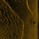
The first instance was while a group of us were on a scanning trip to East Hartford to image a schooner that recently came to our attention in the news, Police officer hoping to solve mystery of sunken schooner. After leaving the boat launch, and before imaging the schooner, I wanted to “play” around with the sonar and image the river bottom from bank to bank. Just at the beginning of our trek north I saw a promising target:
125 meter per side, 400 kHz, east bank on right, west bank on left.

After we finished imaging the river bottom from bank to bank we then focused our attention on the task at hand, imaging “The Schooner” (more on that later). This proved a challenging task due to the shallowness of the site and required a number of hours to accomplish. Time sure does fly when you’re having fun ……..
After we completed our primary task we continued down river to look for the “target of interest” that I had seen earlier. It didn't take long before we found what we were looking for ….. Just a third of a mile from the known schooner shipwreck.
50 meter range, 900 kHz, river flow from left(north) to right (south):

It looks to be a small 8’ x 30’ work barge of some sort.
One more item on the list to visually inspect someday, so much to do so little time ………..
15 meter range:

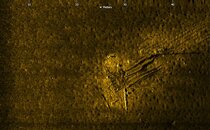
The second instance this past month which triggered the saying Go a mile find a wreck was while scanning shipwrecks off the shore of Bridgeport Connecticut with Tom Hajek on his dive boat Karma. We had just completed an in depth survey of one particular wreck and were transiting to another wreck when we stumbled across a previously uncharted wreck 1.2 nautical miles away.

I had the chance to dive on the wreck this past Tuesday and it’s a small coal barge. The only part of the barge left are the sturdy support timbers (floor timbers?) that made up the bottom of the barge, scattered anthracite pea coal, and one very large (broken) white glazed crock. Viz was terrible so I didn’t shoot any video/pictures. It looks just like the scan though, the bottom timbers are high and exposed at one end and disappear into the muddy bottom on the other end.
So there ya have it, Go a mile find a wreck! That’s one of the things which makes this so much fun, you just never know what you’re going to stumble across. Sometimes it can be hours or days of “mowing the lawn” with no reward while other times the sea gods smile very kindly on us.
Best regards,
Mark
Some of you know that a group of us based out of Mystic Connecticut and Jamestown Rhode Island spend a great deal of time looking for, finding, and diving previously (un)explored shipwrecks. It’s just our passion: time on the water, good friends, the history, the hunt, the exhilaration of discovery, and excitement of diving a new wreck. I’m in the process of “modernizing” my web site and on the new site I’ll have a section where I’ll publish some of the fun we've been up to with New England shipwrecks. My hope is that the information we've accumulated can be more easily enjoyed by a wider base and not by just those directly involved. Until the new web site is fully up and running, the above link points to the old site, I plan on using this forum to accomplish that goal.
Go a Mile Find a Wreck
A good friend of mine and fervent supporter of my side scan sonar work, Larry Lawrence, has a catch phrase that recently proved itself twice in as many weeks, Go a mile find a wreck.
The first instance was while a group of us were on a scanning trip to East Hartford to image a schooner that recently came to our attention in the news, Police officer hoping to solve mystery of sunken schooner. After leaving the boat launch, and before imaging the schooner, I wanted to “play” around with the sonar and image the river bottom from bank to bank. Just at the beginning of our trek north I saw a promising target:
125 meter per side, 400 kHz, east bank on right, west bank on left.

After we finished imaging the river bottom from bank to bank we then focused our attention on the task at hand, imaging “The Schooner” (more on that later). This proved a challenging task due to the shallowness of the site and required a number of hours to accomplish. Time sure does fly when you’re having fun ……..
After we completed our primary task we continued down river to look for the “target of interest” that I had seen earlier. It didn't take long before we found what we were looking for ….. Just a third of a mile from the known schooner shipwreck.
50 meter range, 900 kHz, river flow from left(north) to right (south):

It looks to be a small 8’ x 30’ work barge of some sort.
One more item on the list to visually inspect someday, so much to do so little time ………..
15 meter range:

The second instance this past month which triggered the saying Go a mile find a wreck was while scanning shipwrecks off the shore of Bridgeport Connecticut with Tom Hajek on his dive boat Karma. We had just completed an in depth survey of one particular wreck and were transiting to another wreck when we stumbled across a previously uncharted wreck 1.2 nautical miles away.

I had the chance to dive on the wreck this past Tuesday and it’s a small coal barge. The only part of the barge left are the sturdy support timbers (floor timbers?) that made up the bottom of the barge, scattered anthracite pea coal, and one very large (broken) white glazed crock. Viz was terrible so I didn’t shoot any video/pictures. It looks just like the scan though, the bottom timbers are high and exposed at one end and disappear into the muddy bottom on the other end.
So there ya have it, Go a mile find a wreck! That’s one of the things which makes this so much fun, you just never know what you’re going to stumble across. Sometimes it can be hours or days of “mowing the lawn” with no reward while other times the sea gods smile very kindly on us.
Best regards,
Mark


