Cathedral Re-Visited

Please register or login

Welcome to ScubaBoard, the world's largest scuba diving community. Registration is not required to read the forums, but we encourage you to join. Joining has its benefits and enables you to participate in the discussions.

Benefits of registering include

  • Ability to post and comment on topics and discussions.
  • A Free photo gallery to share your dive photos with the world.
  • You can make this box go away

Joining is quick and easy. Log in or Register now!

Kelly, sadly the vis doesn't dramatically improve. No one has found the Cathedral equivalent to the maxi-blow tunnel, so the improvement goes from 15' to 20', and the difference may be perceptive in nature -- the cave gets a little smaller and you can actually start to see the walls.

I spent a lot of time going through Sheck's hand-written notes recently, and came across a series of visibility reports. The last dive that he has recorded with visibility exceeded 40' was in 1976, it was 60-80. About half of the 42 dives he has recorded from 1971 to 1976 have visibility in the 15-25' range, the other half have 40-80'.

Obviously, there is a source of dirty water somewhere, and if you look at the overlay of the map, it's clear that it goes under several spray fields. But as of yet, no smoking gun. The search continues.

I have seen dive reports where there is some change in clarity,but maybe 10feet at points in penetration. Water samples have been collected at the entrance which is a big culmination of the whole system,but dives pushing out there,this is a great opportunity. For example, there is strong evidence that declining visibility with increasing nutrient count is due to spray fields,but present the entrance data, then everybody will say it is the other guy, make him change his practices. But,for example, you collect entrance data, then another sample site, and say at 8k visibility got better and collected a sample, if the sample at 8k was a better in some key nutrients, then this is something that can be important to water management, DEP etc. There is an opportunity to do some exploration which is great,but there are some great science possibilities here that can help this system,but more importantly help with models with other systems. I think Dr Robert Knight of the Florida Springs Institute would have an interest.
 
It's not just about the exploration.

We've been working with people in SRWMD and Florida A&M since day 1. We've run a datasonde in the system and this weekend will be collecting water samples at various locations up to 2 miles out plus performing a radio location at two spots to validate the survey.

That is awesome. I know that stuff doesn't have a good read in dive reports that are generated.
 
Today was a very good day.

Ted McCoy and Jon Bernot carried cave radio beacons to 5,762' and 10,219', collection water samples at both locations, and carried a Datasonde for the whole trip.

Andy Pitkin, Derek Ferguson, Charlie Roberson, Wade Roberson, and myself located the first beacon in a soy bean field (incredibly close to where we predicted). The 10,219' beacon was located by Andy, Derek, Charlie and Tara Rodgers from SRWMD, once again, Sheck Exley's survey proved to be amazingly accurate.

This afternoon the water samples were delivered to Tom Sawacki at Florida A&M, and the Suwanee River Water Management analyzed the Datasonde data. There might have been a few surprises, including a possible different water source identified 2 miles back and maybe nitrates aren't as high as we were led to believe...
 
Some of you know that I have been spending most of my free time over the past few months working on the Falmouth-Cathedral Springs project, which is a joint project between Karst Underwater Research (KUR) and the Woodville Karst Plains Project (WKPP). I will be writing up a lengthy article in the near future, but Cathedral Canyon is an extensive system which was made famous by Sheck Exley for setting a world record distance penetration in the system, an entire chapter in Caverns Measureless to Man is dedicated to this system.


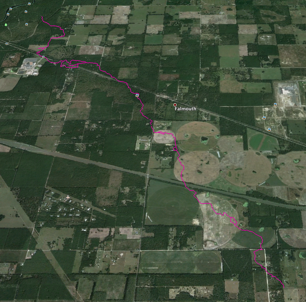
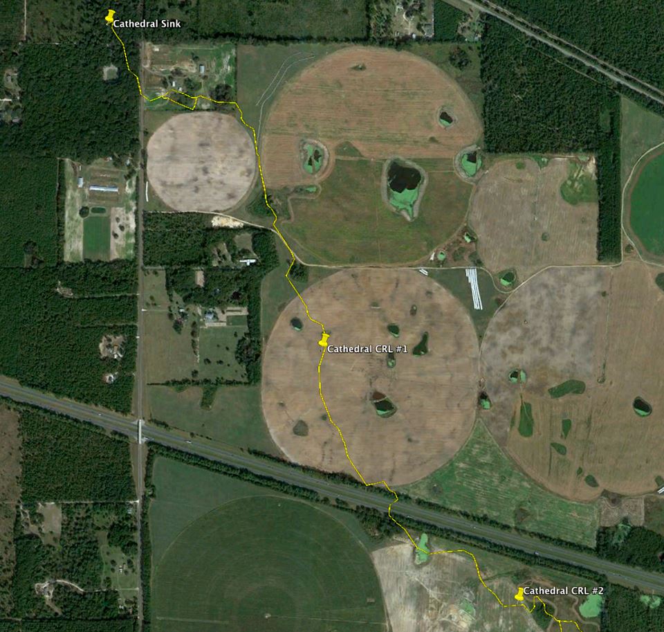
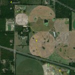
However, the system is also very important as a lesson in how agriculture and development can impact our water resources. The system connects to the Suwannee River at Ellaville Spring, and trends east several miles past the town of Falmouth. The system cuts underneath a chicken processing plant and several farms from the source on it’s way towards the river.


Current exploration of Cathedral has put the cave system out approximately 19,000′ from the nearest entrance. To say that exploration in this system is a challenge would be an understatement, in addition to the large distances from the nearest exit, the visibility tends to run 15′ and the depths vary throughout the system from 70′ to 185′, which can cause sinus problems, in addition to wasting precious inflation gas.


Underwater cave survey is conducted by a simple method – you install a line with knots every 10′ during exploration, and on exit take the azimuth reading every time the system changes direction, and count the knots. Although this system works relatively well, when you start talking distances on the order of 2-3 miles, minor errors can be magnified. A 1 or 2% error in the azimuth, plus a 3-4″ error in the distance for the knots, can put the cave survey off by up to a 1/4 mile at these distances.


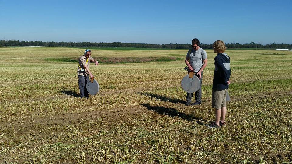
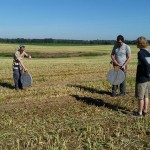
This past weekend, on December 12th, we decided to validate and shore up the survey data by placing radio location beacons in the cave system at 6000′ and 10,200′ penetration. On the surface we then identified where the beacons were placed by using radio locators, which essentially allow us to triangulate in on the signal emitted by the beacons. This did two things for us: it allowed us to validate the survey, and it also gave us proof that the system runs under the spray fields. Additionally, I believe this may be the furthest distance that anyone has successfully deployed and used an underwater radio location beacon.


Here is the impressive thing we discovered: at a distance of 10,200′, Sheck Exley’s survey was off by only 80′. That’s less than a 0.8% error rate — incredibly impressive given that he used 1980’s era technology when he did his exploration.


This weekend would not have been possible without the help of a great team of people. Derek Ferguson needs to be given a lot of credit for coming up with the initial idea for the project, and proposing to do a radio locate at those distances. Jon Bernot and Charlie Roberson have been driving forces for the project, as well as performing some amazing new exploration. Ted McCoy has been an incredibly reliable member of the team — working out logistics in long range exploration, getting the habitat ready, or ready to hop in the water for a 7 hour excursion. Howard Smith has been a silent but steady assistant, always ready to lend a hand and never complaining of the work asked of him. And of course, Andy Pitkin has done an amazing job of converting the raw survey data into a usable format, and organizing and conducting the radio location beacons.
 
maybe nitrates aren't as high as we were led to believe...

Interesting....to me there is something far more important that can be done with the current work that makes exploring 20k miniscule. Please don't get me wrong, a dive of 10k in these conditions is tough, I know 20k is very hard. There is an opportunity to study a system in decline, and acquire hard data of what has caused the decline to exacerbate over time. This hard data gives ammunition to fight naysayers that their practices don't hurt the springshed, and forces government to address the problem. There are some very strong ag interests in this region, that have a lot of money, and officials often would rather turn a blindeye than confront the problem. It has been proven that places like Peacock, Ginnie, Jackson Blue are suffering the same fate, I think the one thing of greatest import and contribution that cave divers can do is protect these spots, and others like it, and collecting hard data is a huge start.
 
12316156_10100490139459115_791689319633417652_n.jpg


We were back at it this weekend.

Friday, Jef and I delivered fresh scooters to 8k, then continued on to 10.5k to check two leads (neither panned out), then pulled the radio location equipment out on our way home. Yesterday Jon and Charlie went to the EOL and dumped a little over 2500', pushing the cave out past four miles.

There will be a full write-up later on.
 
Ken,
I have yet to post your thread but a simply "like" or "thanks" simply does not truly give credit to you and the team for what you are doing.
 
https://www.shearwater.com/products/perdix-ai/
http://cavediveflorida.com/Rum_House.htm

Back
Top Bottom