- Messages
- 10,954
- Reaction score
- 4,139
- # of dives
- None - Not Certified
NONE OF THESE IMAGES ARE CURRENT- Presented for historical purposes only
A topic that often arises, especially during the Summer months and into the end of the year... Tropical Storms and Hurricanes. Understanding how they are created, how they move, and what to look for~ can do a lot to explain whether you might do well to buy trip insurance or just simply book your trip elsewhere during those months.
Obviously, no one can predict whether your trip scheduled for 6 months from now will be a loss, but you can estimate your chances. In the short term, you can easily see if you're headed for trouble next Saturday.
Below are some screen shots taken from the following websites that you will find useful for being a storm watcher.
Jay's Hurricane Images - Real-Time Imagery of Tropical Storms
National Hurricane Center
Hurricanes & Tropical Weather | Weather Underground
Western Caribbean Region - Climatology of Caribbean Hurricanes
Geology News | Earth Science Current Events | Geology.com
Hurricane Archive | Weather Underground (a great historical reference)
http://www.wunderground.com/hurricane/at2013.asp (get the maps by year)
Storms are generated like machine gun bursts off the Equatorial Coast of Africa. They head West. Towards the Caribbean?
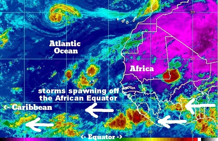
Their ultimate path changes throughout the Tropical Storm (TS) Season. During the early months, they mostly continue Westward, following straight along their mid-Atlantic path, quite often never rising above the 10° Latitude line. You can see nightly displays of lightning in this early period- sit on the ABC islands or the Bay Islands and look South to the mainland. It can be quite a flashy show!
This causes them to make landfall anywhere along the Venezualan Northern coast and continue Westward, then hitting the Central American coast where Nicaragua and Honduras get all of their mainland rains.
As the season progresses, a "lift" comes in the form of winds off of the South American continent, causing the Storms to cycle and lift into the Caribbean (or higher into to SE US coast). These are the storms that make the headlines, as the Caribbean's warm water can really turn a TS into a real live Hurricane. This is when they spin, sweeping in a clockwise arc.
This South American "lift" is also aided by the vacuum created by the Arctic Jet Stream that also has receded northward bringing more bearable summer temperatures to the upper midwest US. This tends to "suck" these Caribbean storm systems along behind it's recession.
As this "lift" occurs as the season evolves, the storm's "entry point" into the Caribbean also moves Northward. The storms edge North from first threatening Tobago, and now make a Westward (usually WNW) through the Lesser Antilles (Grenada, Barbados, St Vincent, St Lucia, Martinique).
As the season ages, this lift becomes more pronounced and as the Tropical Storms also more likely generate into Hurricanes, they begin making entry into the Mar Caribe even further North, now into the Greater Antilles (Dominica, Antigua, Barbuda, St Martin, Anguila, USVI). The islands of Puerto Rico, Cuba and the Bahamas start to feel threatened as well.
Beaufort Scale / MPH / Various Worldwide Nomenclatures
A general "rule":
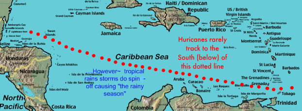
There are notable exceptions over the years, but the above map is pretty accurate.
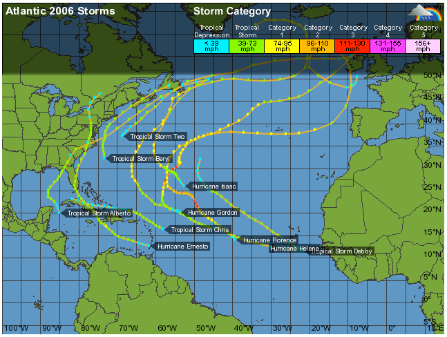
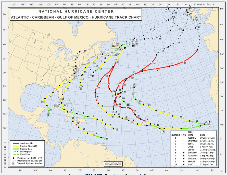
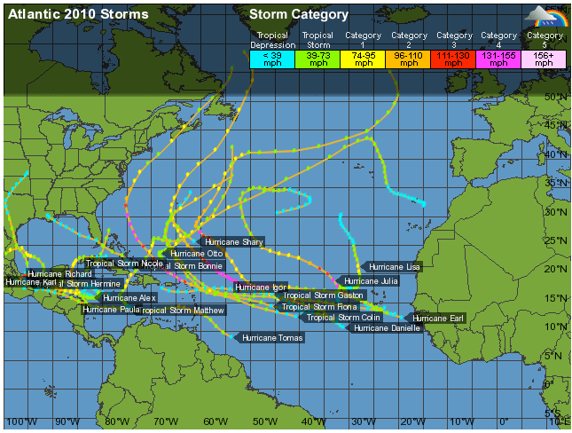
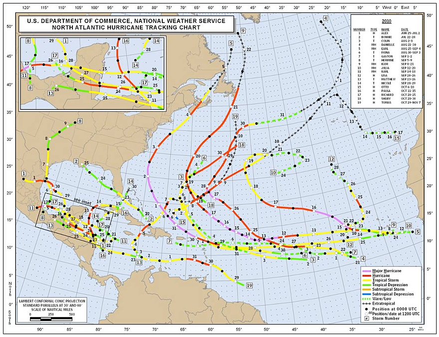
Here are some screen shots of Storm and Hurricane paths over previous years. Note the common patterns that develop.
2006, a year we all hope for... a great "lifting pattern" from South America:
2010, things got more difficult:
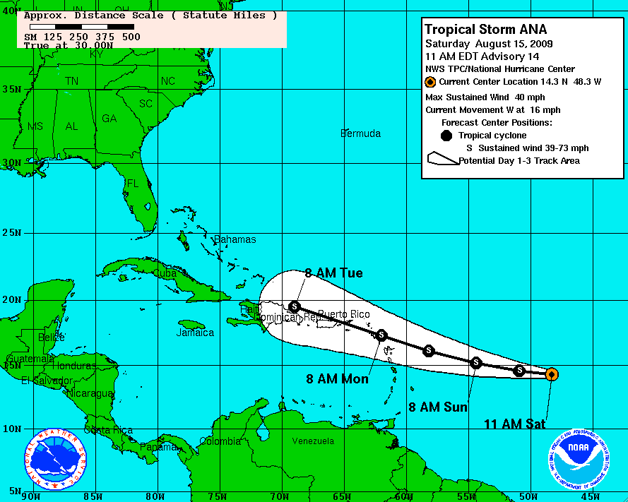
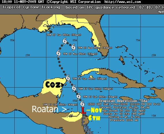
You can see from the NOAA website a good prediction of the potential storm path. It takes some quick study to understand how to read it and utilize it, but this is a phenomenal tool:
another type from NOAA and some other images:
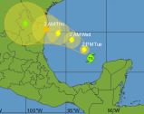
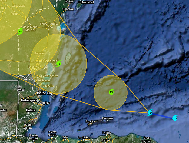
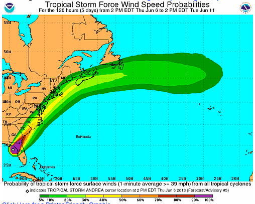
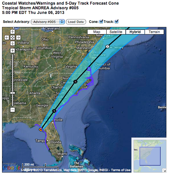
There are no guarantees in life: (this chart shows various predicted path "models" of one TS)
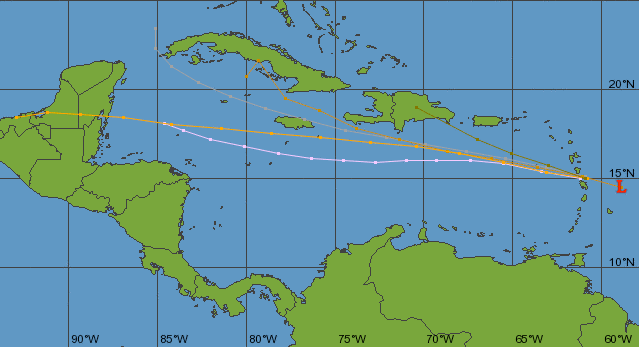
And some are just "free spirits"....
Use the above websites before you need them. Get used to how they work, minimize your chances for a ruined trip.
A topic that often arises, especially during the Summer months and into the end of the year... Tropical Storms and Hurricanes. Understanding how they are created, how they move, and what to look for~ can do a lot to explain whether you might do well to buy trip insurance or just simply book your trip elsewhere during those months.
Obviously, no one can predict whether your trip scheduled for 6 months from now will be a loss, but you can estimate your chances. In the short term, you can easily see if you're headed for trouble next Saturday.
Officially, the Atlantic hurricane season is from June 1 to November 30, but as the Atlantic Oceanographic and Meteorological Laboratory (AOML) notes:
Again according to the AOML, there's a "very peaked season from August to October," which means this period includes:
- "There is nothing magical in these dates, and hurricanes have occurred outside of these six months, but these dates were selected to encompass over 97% of tropical activity."
Again according to the AOML, there's a "very peaked season from August to October," which means this period includes:
- 78% of the tropical storm days
- 87% of the "minor" hurricane days, and
- 96% of the "major" hurricane days
Below are some screen shots taken from the following websites that you will find useful for being a storm watcher.
Jay's Hurricane Images - Real-Time Imagery of Tropical Storms
National Hurricane Center
Hurricanes & Tropical Weather | Weather Underground
Western Caribbean Region - Climatology of Caribbean Hurricanes
Geology News | Earth Science Current Events | Geology.com
Hurricane Archive | Weather Underground (a great historical reference)
http://www.wunderground.com/hurricane/at2013.asp (get the maps by year)
Storms are generated like machine gun bursts off the Equatorial Coast of Africa. They head West. Towards the Caribbean?

Their ultimate path changes throughout the Tropical Storm (TS) Season. During the early months, they mostly continue Westward, following straight along their mid-Atlantic path, quite often never rising above the 10° Latitude line. You can see nightly displays of lightning in this early period- sit on the ABC islands or the Bay Islands and look South to the mainland. It can be quite a flashy show!
This causes them to make landfall anywhere along the Venezualan Northern coast and continue Westward, then hitting the Central American coast where Nicaragua and Honduras get all of their mainland rains.
As the season progresses, a "lift" comes in the form of winds off of the South American continent, causing the Storms to cycle and lift into the Caribbean (or higher into to SE US coast). These are the storms that make the headlines, as the Caribbean's warm water can really turn a TS into a real live Hurricane. This is when they spin, sweeping in a clockwise arc.
This South American "lift" is also aided by the vacuum created by the Arctic Jet Stream that also has receded northward bringing more bearable summer temperatures to the upper midwest US. This tends to "suck" these Caribbean storm systems along behind it's recession.
As this "lift" occurs as the season evolves, the storm's "entry point" into the Caribbean also moves Northward. The storms edge North from first threatening Tobago, and now make a Westward (usually WNW) through the Lesser Antilles (Grenada, Barbados, St Vincent, St Lucia, Martinique).
As the season ages, this lift becomes more pronounced and as the Tropical Storms also more likely generate into Hurricanes, they begin making entry into the Mar Caribe even further North, now into the Greater Antilles (Dominica, Antigua, Barbuda, St Martin, Anguila, USVI). The islands of Puerto Rico, Cuba and the Bahamas start to feel threatened as well.
Beaufort Scale / MPH / Various Worldwide Nomenclatures
| 5 | 17–21 | Fresh breeze | Depression | |||||
| 6 | 22–27 | Strong breeze | ||||||
| 7 | 28–29 | Moderate gale | Deep depression | Tropical depression | ||||
| 30–33 | ||||||||
| 8 | 34–40 | Fresh gale | Cyclonic storm | Moderate tropical storm | Tropical cyclone (1) | Tropical storm | Tropical storm | Tropical storm |
| 9 | 41–47 | Strong gale | ||||||
| 10 | 48–55 | Whole gale | Severe cyclonic storm | Severe tropical storm | Tropical cyclone (2) | Severe tropical storm | ||
| 11 | 56–63 | Storm | ||||||
| 12 | 64–72 | Hurricane | Very severe cyclonic storm | Tropical cyclone | Severe tropical cyclone (3) | Typhoon | Typhoon | Hurricane (1) |
| 13 | 73–85 | Hurricane (2) | ||||||
| 14 | 86–89 | Severe tropical cyclone (4) | Major hurricane (3) | |||||
| 15 | 90–99 | Intense tropical cyclone | ||||||
| 16 | 100–106 | Major hurricane (4) | ||||||
| 17 | 107–114 | Severe tropical cyclone (5) | ||||||
| 115–119 |
A general "rule":

There are notable exceptions over the years, but the above map is pretty accurate.
Here are some screen shots of Storm and Hurricane paths over previous years. Note the common patterns that develop.
2006, a year we all hope for... a great "lifting pattern" from South America:


2010, things got more difficult:


You can see from the NOAA website a good prediction of the potential storm path. It takes some quick study to understand how to read it and utilize it, but this is a phenomenal tool:

another type from NOAA and some other images:


There are no guarantees in life: (this chart shows various predicted path "models" of one TS)

And some are just "free spirits"....

Use the above websites before you need them. Get used to how they work, minimize your chances for a ruined trip.
Last edited:


