Okay, so I'm really looking forward to Bonaire (less than 90 days left, now). Add the fact that I just finished my NAUI Divemaster cert, and I've got a little "spare" time on my hands (relatively speaking). Now, toss in the little detail that I own a laminating machine (for underwater board and card games, actually), and things start getting fun.
So, you see, the thought hit me. I should laminate all the pages from my copy of BSDME (5th Edition) so that I can more easily use them on the trip (and so they won't get all wet and icky). Of course, naturally, the next thought was that I really need to have each laminated sheet be a *single* dive site, as that way I'll be able to use them almost like a deck of cards (hehe, "Pick a dive, any dive..." with the jokers removed, of course). It would just make it more useful. Of course, I only had one copy of BSDME, so...
I just spent quite a few hours, over the weekend and last night, typing the full text of BSDME so that I can print and laminate it as a "divemaster edition" (to go with my actual book). Of course, once you get to that point, you start having... ideas. :biggrin: Why not put a map on the back of each half-sheet page? Why not include GPS coordinates of all the sites for which I can find them online? Why not embellish the plain formatted text pages with icons?
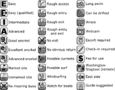
Well, I haven't started on the layout, maps, or GPS coordinates yet (hey, I've got almost three months!), but I have created the complete set of icons I'm going to use to visually present the pertinent information. I can share those, at least, as they're completely my own work. And so, the icons:

(I'll have to upload a PDF of the final product to show off when I'm done. I'll just have to replace all the actual BSDME text with gibberish, but you'll be able to see the layouts and accouterments. )
)
So, you see, the thought hit me. I should laminate all the pages from my copy of BSDME (5th Edition) so that I can more easily use them on the trip (and so they won't get all wet and icky). Of course, naturally, the next thought was that I really need to have each laminated sheet be a *single* dive site, as that way I'll be able to use them almost like a deck of cards (hehe, "Pick a dive, any dive..." with the jokers removed, of course). It would just make it more useful. Of course, I only had one copy of BSDME, so...
I just spent quite a few hours, over the weekend and last night, typing the full text of BSDME so that I can print and laminate it as a "divemaster edition" (to go with my actual book). Of course, once you get to that point, you start having... ideas. :biggrin: Why not put a map on the back of each half-sheet page? Why not include GPS coordinates of all the sites for which I can find them online? Why not embellish the plain formatted text pages with icons?
Well, I haven't started on the layout, maps, or GPS coordinates yet (hey, I've got almost three months!), but I have created the complete set of icons I'm going to use to visually present the pertinent information. I can share those, at least, as they're completely my own work. And so, the icons:
(I'll have to upload a PDF of the final product to show off when I'm done. I'll just have to replace all the actual BSDME text with gibberish, but you'll be able to see the layouts and accouterments.


