- Messages
- 53,667
- Reaction score
- 7,840
- # of dives
- 500 - 999


Welcome to ScubaBoard, the world's largest scuba diving community. Registration is not required to read the forums, but we encourage you to join. Joining has its benefits and enables you to participate in the discussions.
Benefits of registering include
The forecast for Hanna
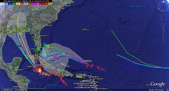
Steering currents imparted by the counterclockwise flow around the upper-level low to its west will keep Hanna moving northwest, to a point midway between Bermuda and the Bahama Islands. About 3-4 days from now, a strong blocking ridge of high pressure is forecast by most of the models to build over Hanna, forcing it to the southwest towards the Bahamas. This is an unusual motion for a hurricane, and it would be surprise to see Hanna move as far south as some of the models are predicting--all the way into Cuba. However, the Bahamas are at high risk from this storm 4-5 days from now. Hanna may be weakening at that time, as wind shear from an upper-level trough to the north of the storm is expected to bring 15-25 knots of shear to the storm. In the longer term, both the ECMWF and GFS models are predicting Hanna will pass through South Florida or the Florida Keys into the Gulf of Mexico by Thursday or Friday next week.
A major complicating factor in forecasting both Hanna's track and intensity may be the possible development of a tropical disturbance behind it, near 18N 41W (see discussion below, under "Elsewhere in the tropics". This disturbance is forecast to develop into a tropical storm 3-5 days from now by some of the models. If so, the new storm could substantially alter the path and strength of Hanna. Don't believe that Hanna will be going through South Florida quite yet; the models do very poorly with hurricane-hurricane interactions, and the long term fate of Hanna is still highly uncertain.
Elsewhere in the tropics
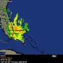
A large circulation is located near 18N, 41W, in the mid-Atlantic Ocean. This morning's QuikSCAT pass show an elongated, poorly formed circulation, with top winds of 25 mph. Heavy thunderstorm activity has increased since yesterday, but the disturbance is battling marginal wind shear of 15-20 knots and dry air on its south side. Wind shear is expected to stay marginal for development over the next few days, limiting this system to only slow development. NHC is giving this system a low (<20% chance) of developing into a tropical depression by Sunday. Some slow development is possible over the next few days, but the system has a better chance 3-5 days from now, when its environment will be moister. Several of the models develop it, and predict the system will be 500 miles or so north of the northern Lesser Antilles Islands by Monday or Tuesday.
The track forecast for Hanna
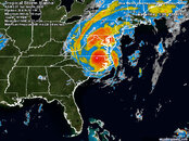
Hanna has been moving erratically over the past day, and has moved considerably farther east than most of the models expected. This decreases the threat to the western Bahama Islands, Florida, and Georgia, since Hanna will be starting further east when it makes its expected turn to the northwest. A landfall location near the South Carolina/North Carolina border is more likely, which would occur Friday night. On Saturday, Hanna will be racing north and then northeast along the U.S. East Coast, bringing tropical storm conditions to the mid-Atlantic and New England states.
The intensity forecast for Hanna
The wind shear is forecast to remain at its current level, 15-25 knots, over the remainder of Hanna's life. There is a large amount of dry continental air lying between Hanna and South Carolina, which will continue to cause problems for the storm. However, sea surface temperatures are a warm 29°C, with a Tropical Cyclone Heat Potential (TCHP) of 40-70, just below the value of 80 typically associated with rapid intensification. The GFDL model intensifies Hanna to a Category 1 hurricane, but the HWRF and SHIPS model keep it a tropical storm. I expect Hanna will have top winds between 60 mph and 80 mph at landfall in North or South Carolina, making it a strong tropical storm or weak Category 1 hurricane.
From Dr.Masters this morning...Wilar said the three were taking a walk on a beach when they were swept away.
The surf was unusually rough from the effects of Tropical Depression Karina.
The forecast for Hanna
A landfall in South Carolina is the unanimous consensus of the the computer models, and this landfall will occur near midnight tonight. Hanna is a large storm with winds well removed from the center. Both North Carolina and South Carolina will see winds of 50-60 mph from this storm. Given that Hanna is so large and fast-moving, the entire mid-Atlantic and New England coast should see sustained winds near tropical storm force (39 mph) this weekend as Hanna zooms northeast.
The wind shear is forecast to remain in the moderate to marginal range, 15-20 knots, over the remainder of Hanna's life. There is a large amount of dry continental air lying between Hanna and South Carolina, which will continue to cause problems for the storm. However, sea surface temperatures are a warm 29°C. None of the intensity models forecast Hanna will become a hurricane, but given the recent increase in the storm's organization, I forecast a 40% chance that Hanna will be a Category 1 hurricane at landfall. Rapid intensification of Hanna is very unlikely, and the strongest I can see this storm getting is a Category 1 storm with top winds of 80 mph. The most likely top winds at landfall will be 70 mph, just below hurricane strength.