...Olga traversing Hispaniola producing heavy rains...
A Tropical Storm Warning remains in effect along the northern coast of Hispaniola from Cabo engano in the Dominican Republic to Le Mole St. Nicholas Haiti.
A Tropical Storm Warning remains in effect for the southeastern Bahamas and the Turks and Caicos Islands.
A tropical storm watch remains in effect for the southern coast of the Dominican Republic from Cabo engano to Punta Palenque.
For storm information specific to your area...including possible inland watches and warnings...please monitor products issued by your local weather office.
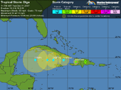
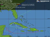
At 1100 PM AST...0300z...the center of Tropical Storm Olga was located inland over Hispaniola near latitude 19.0 north...longitude 70.6 west or about 55 miles... 90 km...northwest of Santo Domingo in the Dominican Republic and about 250 miles...400 km...east-southeast of the eastern tip of Cuba.
Olga is moving toward the west near 15 mph...24 km/hr...and this general motion is expected to continue during the next 24 hours. On this track...the center of a weaker Olga should move over the Windward Passage and then over the waters between Cuba and Jamaica
late Wednesday.
Maximum sustained winds are near 60 mph...95 km/hr...with higher gusts. Olga is expected to weaken to a tropical depression during the next 24 hours.
Tropical storm force winds extend outward up to 240 miles...390 km to the north and east of the center.
Estimated minimum central pressure is 1004 mb...29.65 inches.
Olga is expected to produce additional rain accumulations of 2 to 4 inches over Puerto Rico and the southeastern Bahamas...with isolated maximum storm total amounts of 12 inches over Puerto Rico. Rainfall amounts of 4 to 6 inches are possible over Hispaniola with possible isolated maximum totals of 10 inches. These rains are expected to produce life-threatening flash floods and mudslides in Puerto Rico and Hispaniola.
Repeating the 1100 PM AST position...19.0 N...70.6 W. Movement toward...west near 15 mph. Maximum sustained winds...60 mph. Minimum central pressure...1004 mb. (Why do they repeat in printed messages? Are these read over the air?)
An intermediate advisory will be issued by the National Hurricane Center at 200 am AST followed by the next complete advisory at 500 am AST.
Forecaster Avila


 Falling down on the job!