
Over the years I've been told about dive sites based on the WWII landing site color codes, I've recently started hearing them being referenced by numbers. Anyone have a list of what numbers go with what color code names?

You are using an out of date browser. It may not display this or other websites correctly.
You should upgrade or use an alternative browser.
You should upgrade or use an alternative browser.
Okinawa WWII landing sites
- Thread starter mongodives
- Start date
Please register or login

Welcome to ScubaBoard, the world's largest scuba diving community. Registration is not required to read the forums, but we encourage you to join. Joining has its benefits and enables you to participate in the discussions.
Benefits of registering include
- Ability to post and comment on topics and discussions.
- A Free photo gallery to share your dive photos with the world.
- You can make this box go away
Interrested but I have never heard such a thing...I will be looking forward to see how this string plays out.
OP
Maybe its just a new code to protect "private" dive sites. What got me going on this was seeing Okinawa dive sites referred to as near landing area #x not red, green, gold etc. in other forums.
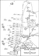
I have the WWII Invasion charts for Okinawa in my car. The overall operationa was called Operation Iceberg with 10th Army General Buckner in charge. The major division were to the North was Hija River/Kadena Town was the Marines who went north, and to the South of the Hija River was the Army who went south with 2 Divisions of Marine and 2 Divisions of Army landing at both locations for the initial invasion. The 6th Marines came ashore later day 10 or so near Camp Kinser and attacked Sugar Loaf Hill. The subs areas during the intial invasion were color codes this looks to be down to Battalion Size. Maybe the smaller lanes Company Size were numbered. Maybe the 6th Marines landing site was numbered or maybe the modern day scuba diver does not know their Okinawa Invasion history. Starting from North to South the landing zones are as follows: 6th Marine Division Green 1 and Green 2, Red 1,2,3. 6th Marine Division Landed Between Yomitan port and the back gate of Torii. 1st Marine Division Blue 1,2 Yellow 1,2. 1st Marine Landed between the backgate of Torii Station and the Hija River. The Army land south of the Hija River. 7th Division had Purple 1,2 and Orange 1,2 they landed at Kadena North area. 96th Division landed from Kadena Marina to Sunabe they had White 1,2,3 and Brown 1,2,3,4.
Last edited:
OP
Barracuda, I got the same info but I don't have the cool map you do.
Like I said before, I think its a new way to keep dive sites secret.
Like I said before, I think its a new way to keep dive sites secret.
Mongodives, I do not have an accurate location where 6th Marine Division came ashore on thier second landing on the Oroku Peninsula around 4 June 1945 but I would assume that there would be many items to be found in that area since it is not dove very often. Also the Japanese made a counter attack in Nakagushu Bay on 22 May 1945, and the US Navy sunk thier entire fleet in the bay. So I believe that there might be many Japanese landing craft down in that bay that are missing. In the 1950's the US Navy pulled many of the known wrecks to deep water to prevent diving accidents. The Japanese were salavaging steel off of a wreck in the Keramas, and when they cut the steel off the hull they set off the magazine and it killed all the divers in the water. Underwater demolitions is not! as the Navy Seals would say. Because water is more dense than air when an explosion happens under water you only need to be close...like with in a mile to be effected or killed. So divers never play with ordinance!
There is much history about the landing sites and much diving that must be done to explore these sites, as the Battle of Okinawa, was one of the bloodist in WWII history.
There is much history about the landing sites and much diving that must be done to explore these sites, as the Battle of Okinawa, was one of the bloodist in WWII history.
There are a few books at the library on base that have the exact maps in question. The first one is the official US Army history of the WWII and is called "Okinawa: the last Battle" and is written by a gentlemen named Appleman. The second is the official US Marine history of WWII and is volume 5 in the series. There is no specific author for this book but the USMC number for is is FMFRP 12-34-V. I know the Foster Library had both as I saw them there a few years ago. Both books have excellent maps and pictures of areas that interest divers...
:w-t-f:You are only allowed to post URLs after you have made 5 posts or more.
http ... // ... : ...
wreckdiving.jp/images/OP_ICEBERG_Landing_Plan.jpg
:w-t-f:
http ... // ... : ...
wreckdiving.jp/images/OP_ICEBERG_Landing_Plan.jpg
Here is the invasion chart attached as a thumbnail
Attachments
Similar threads
- Replies
- 4
- Views
- 319
- Replies
- 14
- Views
- 725
- Replies
- 3
- Views
- 1,051
