New wreck in Sea of Cortez

Please register or login

Welcome to ScubaBoard, the world's largest scuba diving community. Registration is not required to read the forums, but we encourage you to join. Joining has its benefits and enables you to participate in the discussions.

Benefits of registering include

  • Ability to post and comment on topics and discussions.
  • A Free photo gallery to share your dive photos with the world.
  • You can make this box go away

Joining is quick and easy. Log in or Register now!

CycleCat

Contributor
Messages
434
Reaction score
518
Location
near Taos, New Mexico, USA
# of dives
25 - 49
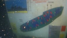
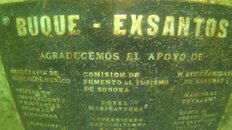
Thursday, March 3, 2022, the Mexican government sank the retired navy ship Santos P106 in a bay near San Carlos/Guaymas, Sonora, to create an artificial reef and interesting dive site for local divers. The 220 foot ship was a WW-II US navy minesweeper known as the USS Gladiator and was sold to the Mexican navy in the 70's. I was told by one of the San Carlos dive shops that the ship lies in about 60 of water.


p106sinking - Edited.png
p106 - Edited.png
 
Thanks for posting.
I tried to find out the location, but nothing. Used to do a lot shore diving in this area. My guess is it's just South of San Carlos. Charters would drop in this bay too. I
 
Thanks for posting.
I tried to find out the location, but nothing. Used to do a lot shore diving in this area. My guess is it's just South of San Carlos. Charters would drop in this bay too. I
Approximate coordinates from Google:

27.934950, -111.065681​


At Punta el Cautin, just west of the marina and Bahia San Carlos. Pretty close to the dive flag on the map.
IMG_0717.jpg
 
Laying claim to the very 1st diver on the wreck after it was opened.

Top of the antenna masts is at 5ft and one of them has already been hit by a boat and is dangling bottom of the stern is sitting at 55ft in the sand.
 

Attachments

  • route.jpg
    route.jpg
    36.9 KB · Views: 134
  • surface marker.jpg
    surface marker.jpg
    98.5 KB · Views: 129
  • Signage.jpg
    Signage.jpg
    74.9 KB · Views: 115
I'll be down there next month and hope to see it then.
 
I'll be down there next month and hope to see it then.

I highly encourage you to check the wind forecast for the days you go diving. It was fairly calm when I got to the wreck and it was great but had 12kt winds by the end of the dive and it turned the inside of of the wreck pretty murky and I was getting tossed around inside from the surge blowing through.
 
They messed up when they sank it. It ended up 90 degrees from where it was supposed to land. It's also way too shallow.
How deep (shallow) is it?
 

Back
Top Bottom