Divectionist
Contributor
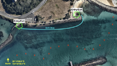
Here is an image of the Tweed River Shore Dive location that shows the underwater rock formations better than usual to assist with navigating the site.
Location: https://goo.gl/maps/1uBZurW8ZSpu1LVG9

Logistics:
If you are visiting this site for the first time, I suggest parking in the indicated area where you can kit up, then walk down to either Entry/Exit points, depending on the tide/timing. There are 2 dive shops in a 5-10min radius. There is a toilet/shower block just beyond the Northern end of the image.
Plan:
I suggest using the Eastern Entry point to enter the water 30-40 minutes before the slack high tide to catch the drift dive towards the Western Entry/Exit point (small beach entry) with good visibility, which is safer than going the other way and ending up in the ocean if you miss the exit. You can easily climb out of the water at the Western Entry/Exit point. Expect to get around 70-80mins runtime on a standard AL80 or LP85 and time your dive around high tide accordingly.
Drift along and bring a powerful torch to inspect the various nooks. You will pass by some waypoints, such as a small buddha statue, big scales, and the little area west of the little bridge near the Western Exit point has a couple shopping trollies to enjoy. After the drift, you could spend your time searching around the left half of the dive area shown in the map, and around the pillars of the bridge structure near the exit.
Navigation could not be easier, turn around if you hit sand and heading North will always take you back to the wall. Make sure you do not surface away from the wall (bring a DSMB just in case) as there is boat traffic.
Makes for a fun night dive also. Parts of the river a few hundred metres further inland can also be drifted, particularly if you time the tide to take you back to your entry point.
Depth:
ca. 12m max if you look for it
ca. 8-9m usual max on a dive
ca. 5-7m average depth on a dive
Topography:
Boulder/rock wall
Coffee rock bottom
Sand bottom
Conditions:
5-15m+ vis with a 10m average
Water temperature 19-27C
Avoid diving after heavy rain (bad vis)
Avoid diving after Northerly winds (bad vis)
Avoid low tide or strong tidal flow periods (bad vis)
Dangers:
Stonefish
Current
Fishing line
OW classes
Marine life:
Common locals are octopus, turtles, rays, dolphins, lionfish, frogfish, pipefish, nudibranchs, etc.
Location: https://goo.gl/maps/1uBZurW8ZSpu1LVG9
Logistics:
If you are visiting this site for the first time, I suggest parking in the indicated area where you can kit up, then walk down to either Entry/Exit points, depending on the tide/timing. There are 2 dive shops in a 5-10min radius. There is a toilet/shower block just beyond the Northern end of the image.
Plan:
I suggest using the Eastern Entry point to enter the water 30-40 minutes before the slack high tide to catch the drift dive towards the Western Entry/Exit point (small beach entry) with good visibility, which is safer than going the other way and ending up in the ocean if you miss the exit. You can easily climb out of the water at the Western Entry/Exit point. Expect to get around 70-80mins runtime on a standard AL80 or LP85 and time your dive around high tide accordingly.
Drift along and bring a powerful torch to inspect the various nooks. You will pass by some waypoints, such as a small buddha statue, big scales, and the little area west of the little bridge near the Western Exit point has a couple shopping trollies to enjoy. After the drift, you could spend your time searching around the left half of the dive area shown in the map, and around the pillars of the bridge structure near the exit.
Navigation could not be easier, turn around if you hit sand and heading North will always take you back to the wall. Make sure you do not surface away from the wall (bring a DSMB just in case) as there is boat traffic.
Makes for a fun night dive also. Parts of the river a few hundred metres further inland can also be drifted, particularly if you time the tide to take you back to your entry point.
Depth:
ca. 12m max if you look for it
ca. 8-9m usual max on a dive
ca. 5-7m average depth on a dive
Topography:
Boulder/rock wall
Coffee rock bottom
Sand bottom
Conditions:
5-15m+ vis with a 10m average
Water temperature 19-27C
Avoid diving after heavy rain (bad vis)
Avoid diving after Northerly winds (bad vis)
Avoid low tide or strong tidal flow periods (bad vis)
Dangers:
Stonefish
Current
Fishing line
OW classes
Marine life:
Common locals are octopus, turtles, rays, dolphins, lionfish, frogfish, pipefish, nudibranchs, etc.