Hurricane Ike Looks at Northern Antilles, T&Cs, Bahamas

Please register or login

Welcome to ScubaBoard, the world's largest scuba diving community. Registration is not required to read the forums, but we encourage you to join. Joining has its benefits and enables you to participate in the discussions.

Benefits of registering include

  • Ability to post and comment on topics and discussions.
  • A Free photo gallery to share your dive photos with the world.
  • You can make this box go away

Joining is quick and easy. Log in or Register now!

Finished with Haiti, T&Cs, southern Bahamas, and Ike continues traveling the length of Cuba. The Florida Keys may be spared, and the evacuation has been suspended but return has been discouraged until Wednesday. Looks like Ike is dumping rain bands on the Caymans, may just miss Cancun, and head for Texas or northern Mexico - subject to change over the week....


Thnx for all the updates
 
Just found this thread & haven't read any replies, but I've been following Ike for several days let's say......Looks like the lower Texas coast is a posssibility now, maybe close to CC???.......Good luck to ALL, here's hoping he shoots his wad before the FG and turns into nothing.......BTW, hope the FG makes it OK..........

www.crownweather.com........click on Ike.......
 
Thnx for all the updates
Kind of a digest of a better site I hope. YVW.
Just found this thread & haven't read any replies, but I've been following Ike for several days let's say......Looks like the lower Texas coast is a posssibility now, maybe close to CC???.......Good luck to ALL, here's hoping he shoots his wad before the FG and turns into nothing.......BTW, hope the FG makes it OK..........
The Ike would be a part of the natural cycle for the FG, but rough on any activities there. I'm sure the boats would stay in safe harbor.

Looks like he's going to drift further south, more towards the Rio Grande Vally this morning - except the wind map and some of the models don't seem to agree with the others? He's big enough to rain on the Yucatan with this track I suppose. New Orleans can breathe easier maybe...
 

Attachments

  • Ike 1.gif
    Ike 1.gif
    32.3 KB · Views: 53
  • Ike 2.gif
    Ike 2.gif
    36.5 KB · Views: 67
  • Ike 3.gif
    Ike 3.gif
    29.4 KB · Views: 63
  • Ike 4.jpg
    Ike 4.jpg
    182.7 KB · Views: 52
Rain bands from Cozumel to Tampa! :shocked2: The computer models are starting to agree on the Corpus Christi area for ground zero, altho the carnage will be broad and the storm surge will cover 100+ miles of shore. I'm sure that Houston doesn't want to repeat the Rita fiasco. Refineries have not shut down anywhere yet I don't think altho many platforms will be evacuated. Looks like it'll be bad on our coast by Saturday, then breakup over the state following - maybe even raining on me up here on the Panhandle-High Plains

From:Evacuations in Texas as deadly Ike moves in | NEWS.com.au
PRESIDENT George W Bush declared an emergency in Texas today and state authorities began ordering evacuations as deadly Hurricane Ike churned in the Gulf of Mexico towards the US state.
The presidential declaration frees federal aid to boost local efforts, as the state girds for expected landfall later this week by Ike, which is forecast to pick up speed and become a major hurricane before slamming the Texas coast.

A mandatory evacuation order was to go into effect in the coastal area immediately south of Galveston, Texas, early today, Brazoria County officials said.

Ike has now moved into the Gulf of Mexico, home to the bulk of US oil producers, and is headed toward the southern Texas coastline where it could strike land early Saturday, according to the National Hurricane Centre.

Anglo-Dutch oil giant Shell said it would complete evacuating personnel from its offshore installations by today.
 

Attachments

  • Ike.gif
    Ike.gif
    32.3 KB · Views: 54
  • Ike2.gif
    Ike2.gif
    36.3 KB · Views: 60
  • ike3.gif
    ike3.gif
    34.3 KB · Views: 61
  • ike_path.jpg
    ike_path.jpg
    92.3 KB · Views: 49
  • Screen02_edited.JPG
    Screen02_edited.JPG
    203.6 KB · Views: 56
Ike is a really nasty one. This is not one to get "hurricane fatigue" over. This is one to run from.

Wunder Blog : Weather Underground

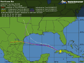
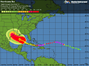
Comparisons to Carla and Katrina

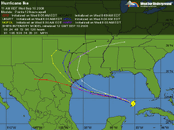
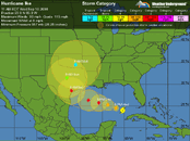
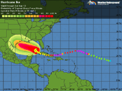
Ike is larger than Katrina was, both in its radius of tropical storm force winds--275 miles--and in it radius of hurricane force winds--115 miles. For comparison, Katrina's tropical storm and hurricane force winds extended out 230 and 105 miles, respectively. Ike's surge will probably rival the massive storm surge of Hurricane Carla of 1961. Carla was a Category 4 hurricane with 145 mph winds at landfall, and drove a 10 foot or higher storm surge to a 180-mile stretch of Texas coast. A maximum storm surge of 22 feet was recorded at Port Lavaca, Texas. Despite the fact that the center of Carla hit over 120 miles southwest of Houston, the hurricane drove a 15-foot storm surge into the bays along the south side of the city. Ike's maximum surge is not likely to reach the extreme values above 20 feet seen in Hurricane Carla, though.

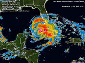
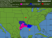
The total energy of Ike

The amount of water Ike has put in motion is about 10% greater than what Katrina did, and thus we can expect Ike's storm surge damage will be similar to or greater than Katrina's. The way we can estimate this damage potential is to compute the total energy of Ike's surface winds (kinetic energy). To do this, we must look at how strong the winds are, and factor in the areal coverage of these winds. Thus, we compute the Integrated Kinetic Energy (IKE) by squaring the velocity of the wind and summing over all regions of the hurricane with tropical storm force winds or higher. This "Integrated Kinetic Energy" was recently proposed by Dr. Mark Powell of NOAA's Hurricane Research Division as a better measure of the destructive power of a hurricane's storm surge than the usual Category 1-5 Saffir-Simpson scale. For example, Hurricane Katrina hit Mississippi as a strong Category 3 hurricane, yet its storm surge was more characteristic of a Category 5 storm. Dr. Powell came up with a new scale to rate potential storm surge damage based on IKE (not to be confused with Hurricane Ike!) The new scale ranges from 1-6. Katrina and Wilma at their peaks both earned a 5.1 on this scale (Figure 2). At 12:30pm EDT today, Ike earned a 5.2 on this scale, the second highest kinetic energy of any Atlantic storm in the past 40 years. Hurricane Isabel of 2003 had the highest. Note that the figures I quoted in this morning's blog saying Ike had an IKE of 180, 50% higher than Katrina's, were found to be in error due to some bad data from one of the Hurricane Hunter observations (the IKE is an experimental product, after all). Thus, this morning's IKE was actually a little lower than Katrina's.

and from:

Texas prepares for a gigantic Hurricane Ike - Yahoo! News

But the storm was so big, it could inflict a punishing blow even in those areas that do not get a direct hit. Forecasters warned that because of Ike's size and the state's shallow coastal waters, it could produce a surge, or wall of water, 20 feet high, and waves of perhaps 50 feet. It could also dump 10 inches or more of rain.

"It's a big storm," Texas Gov. Rick Perry said. "I cannot overemphasize the danger that is facing us. It's going to do some substantial damage. It's going to knock out power. It's going to cause massive flooding."

Perhaps the sternest warning came from the National Weather Service for residents along a Gulf-facing stretch of Galveston Island and neighboring Bolivar Peninsula, which are both under mandatory evacuation orders. People ignoring the orders in single-family one- or two-story homes "will face certain death," read the statement Thursday from the local weather forecast office.
 
This morning's forecast show the computer models pretty well unanimous on landfall very near Houston and this afternoon's seem more in agreement, Cat-3 expectations even in the city followed by Cat-1 expectations as he approaches Dallas and Tropical Storm watches into Oklahoma and Arkansas. Oil platforms are closing in the Gulf with a quarter of the US refineries being closed. Yeah, it's going to be a tremendous blow to some of our most populated and vulnerable area as well as to the US economy.

Travelers with Houston or Dallas connections this weekend might be well advised to make other arrangements. The airlines are allowing no fee changes for those and many other airports. I'd certainly hate to get stuck in either; hotels are possibly full with evacuees.

We're getting extended rain in the Panhandle from the moisture that Lowell pumped in crossing Baja.
 

Attachments

  • Ike.gif
    Ike.gif
    39.4 KB · Views: 55
  • Ike2a.gif
    Ike2a.gif
    34.3 KB · Views: 58
  • ike3.gif
    ike3.gif
    34.1 KB · Views: 57
  • Ike5.gif
    Ike5.gif
    27.1 KB · Views: 56
LIFE THREATENING INUNDATION LIKELY!

ALL NEIGHBORHOODS...AND POSSIBLY ENTIRE COASTAL COMMUNITIES...
WILL BE INUNDATED DURING THE PERIOD OF PEAK STORM TIDE. PERSONS
NOT HEEDING EVACUATION ORDERS IN SINGLE FAMILY ONE OR TWO STORY
HOMES MAY FACE CERTAIN DEATH. MANY RESIDENCES OF AVERAGE
CONSTRUCTION DIRECTLY ON THE COAST WILL BE DESTROYED. WIDESPREAD
AND DEVASTATING PERSONAL PROPERTY DAMAGE IS LIKELY ELSEWHERE.
VEHICLES LEFT BEHIND WILL LIKELY BE SWEPT AWAY. NUMEROUS ROADS
WILL BE SWAMPED...SOME MAY BE WASHED AWAY BY THE WATER. ENTIRE
FLOOD PRONE COASTAL COMMUNITIES WILL BE CUTOFF. WATER LEVELS MAY
EXCEED 9 FEET FOR MORE THAN A MILE INLAND. COASTAL RESIDENTS IN
MULTI-STORY FACILITIES RISK BEING CUTOFF. CONDITIONS WILL BE
WORSENED BY BATTERING WAVES CLOSER TO THE COAST. SUCH WAVES
WILL EXACERBATE PROPERTY DAMAGE...WITH MASSIVE DESTRUCTION OF
HOMES...INCLUDING THOSE OF BLOCK CONSTRUCTION. DAMAGE FROM
BEACH EROSION COULD TAKE YEARS TO REPAIR.

VERY DANGEROUS WINDS WILL PRODUCE WIDESPREAD DAMAGE AND
DESTRUCTION OF MOBILE HOMES IS LIKELY.

STRUCTURAL DAMAGE WILL INCLUDE THE MAJORITY OF MOBILE HOMES BEING
SEVERELY DAMAGED. THOSE THAT SURVIVE WILL BE UNINHABITABLE UNTIL
REPAIRED. HOUSES OF POOR TO AVERAGE CONSTRUCTION WILL HAVE MAJOR
DAMAGE...INCLUDING PARTIAL WALL COLLAPSE AND ROOFS BEING LIFTED
OFF. MANY WILL BE UNINHABITABLE. WELL CONSTRUCTED HOUSES WILL
INCUR MINOR DAMAGE TO SHINGLES...SIDING...GUTTERS...AS WELL AS
BLOWN OUT WINDOWS. UP TO ONE QUARTER OF GABLED ROOFS WILL FAIL.

PARTIAL ROOF FAILURE IS EXPECTED AT INDUSTRIAL PARKS...ESPECIALLY
TO THOSE BUILDINGS WITH LIGHT WEIGHT STEEL AND ALUMINUM
COVERINGS. OLDER LOW RISING APARTMENT ROOFS MAY ALSO BE TORN
OFF...AS WELL AS RECEIVING SIDING AND SHINGLE DAMAGE. UP TO ONE
QUARTER OF ALL GLASS IN HIGH RISE OFFICE BUILDINGS WILL BE BLOWN
OUT. AIRBORNE DEBRIS WILL CAUSE DAMAGE...INJURY...AND POSSIBLE
FATALITIES.

NATURAL DAMAGE WILL INCLUDE ALL TREES WITH ROTTING BASES BECOMING
UPROOTED OR SNAPPED. NEARLY ALL LARGE BRANCHES WILL SNAP. BETWEEN
ONE QUARTER AND ONE HALF OF HEALTHY SMALL TO MEDIUM SIZED TREES
WILL BE SNAPPED OR UPROOTED...MOST COMMON WHERE THE GROUND IS
SATURATED. UP TO THREE QUARTERS OF NEWLY PLANTED GROUND CROPS
WILL BE DAMAGED.

i can't believe there are people who are going to try to ride this one out...
 
i can't believe there are people who are going to try to ride this one out...
This is the first major one for Houston in 25 years, and Rita's evacuation fiasco followed by the miss reduced the number who would take the warnings seriously. It's going to be bad.
 
Just spoke to my son in Metairie, La. and they are getting some bands from Ike. Schools closed and 50-70 mph gusts. If that's just outer bands, I can imagine what is in store.

May God Bless those in it's path.
 
https://www.shearwater.com/products/peregrine/

Back
Top Bottom