Hurricane Ike Looks at Northern Antilles, T&Cs, Bahamas

Please register or login

Welcome to ScubaBoard, the world's largest scuba diving community. Registration is not required to read the forums, but we encourage you to join. Joining has its benefits and enables you to participate in the discussions.

Benefits of registering include

  • Ability to post and comment on topics and discussions.
  • A Free photo gallery to share your dive photos with the world.
  • You can make this box go away

Joining is quick and easy. Log in or Register now!

My backdoor is 10 foot from the water, I'm not all that interested in the math. Do I go or do I stay, if I head north will I be going into the hurricane or should I stay put. If they can't tell me that I wish they would lay off the constant newspaper and television coverage. THE CONE is doing me no good at all. It comes down to maybe yes, maybe no with all the math and science being equal to the magic 8 ball when it comes to making a decision.

I can't control the press. They love that stuff. I imagine that they're drooling for Florida to take a big hit to boost ratings. Best advice is to move to New Mexico or Arizona. :eyebrow:
 
Looks like Ike is serious business...

From Cape Verde-type hurricane - Wikipedia, the free encyclopedia
A Cape Verde-type hurricane is an Atlantic hurricane that develops near the Cape Verde islands, off the west coast of Africa. The average hurricane season has about two Cape Verde-type hurricanes, which are usually the most intense storms of the season because they often have plenty of warm open ocean over which to develop before encountering land.
The Galveston 1900 and Miami 1926 hurricanes - the two biggest killers in US storm history - were Cape Verde-type storms. From Dr. Masters...
Ike
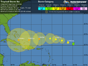
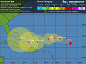
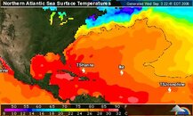
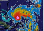
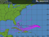
Tropical Storm Ike continues getting organized over the middle Atlantic, and has the potential to become a large and dangerous Cape Verdes-type hurricane by Monday, when it is expected to be in the southeastern Bahama Islands. Visible satellite loops show that heavy thunderstorm activity is starting to wrap around the core of the storm, and Ike has about 50% of an eyewall built. Upper-level outflow is good, and Ike is in a very favorable upper-level wind environment, with an upper-level anticyclone overhead, and wind shear less than 10 knots. Ike has moistened the atmosphere around it enough to wall off a large amount of dry air that surrounds it. Rather cool sea surface temperatures (SSTs) of 27.5°C. SSTs will quickly warm to 29°C over the next two days, but the shear is forecast to increase to 20-35 knots Thursday through Friday. The SHIPS model responds by strengthening Ike only to a Category 1 hurricane today, then weakening it to a tropical storm during the higher shear, then strengthening it again to a Category 1 hurricane by Saturday. The HWRF and GFDL models do not predict the shear will affect Ike as much Thursday and Friday, and intensify the storm into a Category 2 or higher hurricane by Sunday. The HWRF makes Ike a Category 4 hurricane in the eastern Bahama Islands on Monday, and the GFDL has Ike hitting eastern Cuba as a Category 2 or 3 hurricane on Monday. I expect Ike to be a hurricane by Thursday morning, and a Category 3 or higher hurricane by Monday.

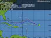
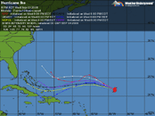
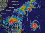
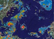
The longer term fate of Ike is highly uncertain. The ECMWF and GFS models both forecast that Hanna will be strong enough to create a weakness in the ridge of high pressure steering Ike to the west. Ike will then follow Hanna's path, recurving northwards. the timing of this recurvature is critical, as the GFS shows that Ike will miss the U.S., while the ECMWF forecasts a strike in South Florida on Tuesday, then another landfall in North Carolina later in the week. If Hanna is not as strong or is faster-moving than these models expect, Ike may not recurve. Instead, Ike will cross Cuba or move through the Florida Straits, eventually emerging into the Gulf of Mexico to cause havoc there.
 

Attachments

  • Ike.gif
    Ike.gif
    35.3 KB · Views: 64
  • Ike2.gif
    Ike2.gif
    34.9 KB · Views: 62
I can't control the press. They love that stuff. I imagine that they're drooling for Florida to take a big hit to boost ratings. Best advice is to move to New Mexico or Arizona. :eyebrow:

I've driven I-10 through both states, there's a whole lot of nothing out there, I'll take an occasional hurricane
 
With things always subject to change, Ike has taken a big jump in power already, now Cat-4. I cannot imagine steady winds of over 130 miles/hour. :shocked2: Current projections are for him to retain power in the Cat-3 to 4 range as he skims Hispaniola & Cuba, hits the T&Cs and Bahamas where he will be crossing even warmer waters than now - then on possibly to Florida where his angle of approach could even take in all of the state. With only 4 shopping days left, I hope everyone there is stocked up and prepared for a bad one....
 

Attachments

  • Ike.gif
    Ike.gif
    35.1 KB · Views: 60
  • Ike2.gif
    Ike2.gif
    37.4 KB · Views: 60
  • ALT water temps.JPG
    ALT water temps.JPG
    34.5 KB · Views: 57
  • Screen01.JPG
    Screen01.JPG
    89.2 KB · Views: 50
  • Screen02.JPG
    Screen02.JPG
    89.8 KB · Views: 57
  • Screen03.JPG
    Screen03.JPG
    88.3 KB · Views: 51
that is crazy fast intensification.

it'll be interesting to see how well the cat4 eyewall can protect it from increasing wind shear and how large the wind field will grow to...
 
It's a full blown hurrincane, currently a cat 4 and this one will be bad. 145 mph steady winds with gusts to 185.

at200809_5day.gif
 
This will give an idea about why projections change so much so quickly. From Dr.Masters...
Ike's long-term fate has two main possibilities:

1) Ike may hit eastern Cuba, as forecast by the latest (12Z, 8am EDT) runs of the GFDL and ECMWF models, and a number of ensemble members of the latest 12Z GFS model (Figure 2). A hit on Cuba would severely disrupt the storm, weakening it to a Category 1 or 2. Ike could then move on into the Gulf of Mexico and re-intensify, as forecast by the ECMWF model.

2) Ike may plow through the Bahamas and come very close to South Florida (the consensus of the HWRF, NOGAPS, and GFS models). A trough of low pressure may then pull Ike to north. This turn to the north might occur over Florida, or over the western Bahamas, within 200 miles of the Florida coast. In the latter case, North Carolina might be at risk. The recent model trend has been to depict a weaker trough, resulting in Ike getting stranded, like Fay and Gustav did. Ike would resume a slow motion to the west as ridge of pressure builds in, potentially crossing Florida into the Gulf of Mexico.

There is a third possibility--Ike may recurve before hitting the U.S., and move harmlessly out to sea. That possibility appears lower probability than cases 1 and 2 above, at this point.
Whether Ike heads off into the Gulf, to the Caribbean, or up thru Florida, he's bad....
 

Attachments

  • Ike.gif
    Ike.gif
    32.9 KB · Views: 75
at least the shear is pulling ike apart and weakening it rather than intensifying it.

That is lame news and will undoubtedly disappoint the TV stations and newspapers. Darn.
 
That is lame news and will undoubtedly disappoint the TV stations and newspapers. Darn.
Not enough to relax I don't think. He may drop to Cat-2 soon but bounce back over warmer waters - expected to be back to Cat-3 by Saturday night and winds in excess of 110 miles/hour are still tremendous. Flooding is the major risk to life tho. Subject to change, he's expected to inflict heavily on the T&Cs, maybe all of the Bahamas, then possible all of Florida before who knows what next. Looks like a high alert situation for anyone between Purto Rico and Jacksonville FL - unless he rolls over Cuba weakened to re-energize in the Caribbean, or over Key West to come alive in the Gulf. Someone is probly going to pay dearly; hope all are prepared and most flying to Denver.
 
https://www.shearwater.com/products/swift/

Back
Top Bottom