Hurricane Gustav

Please register or login

Welcome to ScubaBoard, the world's largest scuba diving community. Registration is not required to read the forums, but we encourage you to join. Joining has its benefits and enables you to participate in the discussions.

Benefits of registering include

  • Ability to post and comment on topics and discussions.
  • A Free photo gallery to share your dive photos with the world.
  • You can make this box go away

Joining is quick and easy. Log in or Register now!

DAN travel insurance certainly covers hurricanes. Both Peter Hughes and Aggressor promote it (and PH is including it during hurricane season, for that very reason.)
 
A Saturday flight into Grand isn't looking particularly likely, and a few days after that, then southern Florida might be in mischief from TS Hana.

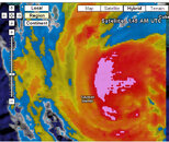
Current track for Gustov is taking its center somewhere between Grand Cayman and Little Cayman ... roughly a 75 mile stretch. After last nights big shift west, the Weather Underground computer models seem to be shifting (correcting?) back eastwards.. the extreme western track puts it off Grand Cayman's East End, and the extreme eastern track puts it between LC and the Brac.

As of this update, it looks like Little Cayman is going to be most heavily hit, and that the storm will by my reckoning pass at around midnight tonight. As to where, see my comment further below on winds.


Here's some Grand Cayman East End webcams:

CaymanChillin.com - Web Cams

Grand Cayman Diving Resort | Compass Point, East End, Cayman IslandsCompass Point

Ocean Frontiers - Grand Cayman Islands, Scuba Diving, Snorkeling, Vacation Packages


For live conditions closer to LC & the Brac, there's still no live webcams that I know of, but there is a new government-run weather station on the Brac (LC is getting one "soon") that started up this summer.

Here is the Brac live weather station feed.

I've been watching the Brac's feed for a couple of weeks. What I've generally found is that the winds are a lot lower than I'd generally expect, so I suspect that the gage is somewhere that's somewhat sheltered a little from the normal SE tradewinds.

In watching it today, I've been noticing some data drops...so be patient with the feed.

The winds had been very low (<5mph) until Wednesday. They really came up some late on Thursday and were ~10mph until around noon today before picking up.

In case this Brac weather station goes down shortly, here's the current (2:30pm-3:00pm EDT) conditions being reported on the Brac:

Cloud Base (altitude): 650ft
Barometer: 997.0 millibars; dropping at -2.0 mb/hour
Temperature: 72.5F
Dew Point: 69.6F
Rain so far today: 0.47" Currently light rain.

Wind direction: 38 degrees (NE)
Wind Speed: 30mph+; max 39.7mph
Wind Gusts: 21mph, 39.7mph
Wind Gust/Last Hour: 39.1mph

Winds comment:

As important as the wind speed is the wind direction and its progression. In simple terms, if the winds progress counter-clockwise (East->North->West), then the center of the storm is passing to the West/South, whereas if the winds go clockwise (East->South->West), then the storm is passing to the East/North.

One reason why this is important is if they don't progress, then the storm's heading dead-on straight for you.

In trying to read these tea-leaves...and with some faith that the models are claiming that the storm will pass to the west of the Brac (where this weather station is), I've been watching for evidence of directional changes. I have noticed some transient 'gusts' that are coming in at 71 degrees (ENE)...but this would indicate a clockwise progression, which is contrary to the projected path. Hmmm.

In general, if you have a choice as to which side of a storm to be on, the rule of thumb is to be on the 'weak' side, which means that the storm is to your East. For the Sister Islands, this is a 'good thing' in terms of the resorts, since this minimizes winds from the South (where the resorts are...and their diveboat docks), but it is bad for the locals on the Brac, as most of them live on the North side. Similarly, Bloody Bay is on the north side too, so this means more wave/surf-type action to stir things up and damage the reefs.


-hh

PS:

Some waves and shoreline during TS/Hurricane Lily on the Brac...3 Oct 2002.


PPS: Storm Carib Web Tool: "How Close Can it Get?"

(current projection: ~17.5 miles from roughly LCBR)
 
Last edited:
Looks like he's just arriving in the area, will be mostly gone in the morning with lingering rain maybe...

Screen02_edited.JPG Screen03_edited.JPG Gus.gif Gus 2.gif Gus 3.gif
 
Anyone who is actually in Caymen have a weather update?
 
Anyone who is actually in Caymen have a weather update?
At the moment, Weather Channel Desktop showing Greogetown Grand Cayman with 82F, wind NNE @ 23 mi/hr.
 

Attachments

  • Screen01_edited.JPG
    Screen01_edited.JPG
    282 KB · Views: 46
Just heard in from the Brac (northside);

Looks like peak winds there were ~60mph; power is out and expected to be down 24-48 hours due to number of Poles down. Allegedly, South Side took a bit of a beating ...

Got an indirect report last night that Little Cayman had 100mph winds ... possible, as Gustov passed closer to them (~15 miles to the west of LC).

IMO, quite likely that the dive operations' docks on LC are gone; maybe the Brac too...I'm hoping for an update on the Brac's southside w/ photos by later this afternoon; he'll probably have LC news by then too.

Current conditions on the Brac: 20mph wind from SSE; 8" of rain yesterday and 1.5" so far today. Barometer 1001 mb; rising at 1.5 mb/hour.


-hh
 
On Grand Cayman, some power lines & tree branches came down, but nothing more major than that. Power is back on in my area. There is almost no wind now. I STILL think there will be diving on Mon. AM.
 
I pray that no one was hurt or injured as Gustav passed by the Cayman Islands.

I"ve got a trip planned for the 14th - 20th Sep 08 for LCBR and GC. I wonder will everything be up and running at that time. Does anyone have any idea to the extent of damage done to LCBR?

What do you think will happen now? Will they be operational within a week or so?

Thanks
 
Paraphrased...

#1: no reports of casualties on the Brac.

Reconnaissance drive - Brac southside from ~2 miles East of Bluff Road to Coral Isle at the west end. Lines down at Coral Isle, blocking access to the west end, where the condos/resorts (Brac Caribbean, Carib Sands, Divi, Brac Reef), are, so still waiting for eyewitness info from there.

Plus I personally know that the bend in the road at Captain's Table will be flooded, which can only be negotiated with a larger truck-type vehicle...my guess would be 12" of water on the road, plus or minus.

Continuing from the report:

"Some [Brac southside] houses have quite severe damage to roofs and porch overhangs but did not see any total roof destruction. Wave action must have been "impressive" to say the least judging by how far rocks have been moved out of ocean/off ironshore and into the bush or onto the road..."

Unconfirmed reports:

- that Brac Reef Resort Pier and Divi Pier + a couple of other smaller ones have gone... positive info ASAP.

- that a couple of structures in LYB got hit badly - roofs off etc - again, I stress that these are unconfirmed reports

In cleanup,

"CYB Power and Light have already managed to restore Mains Power to a swathe, n North Side from the Power Plant West past Stake Bay."


Photos from Mike 'soon'; he's still attempting to get solid word from Little Cayman.


-hh
 
https://www.shearwater.com/products/swift/

Back
Top Bottom